3 Jan 2016

1001 done - the maps


These are the A3 paper maps filled in with green marker that I used to chart which streets I'd walked. A lot of streets I walked down several times and the rule was to only count them once. Cul-de-sacs could also be said to have been walked twice - if you were pedantic about that sort of stuff - by walking down them and back. But from time to time there were alleyways (bless 'em) that came to the rescue, which is why the blog has so much praise of alleyways.

Naturally there were new areas that didn't appear on the map, and a few areas on the fringes that didn't get a map printed, including Forrestdale, the Brookwood Estate and Bedfordale.


Champion Lakes, Kelmscott and Clifton Hills.

Piara Waters and Harrisdale - got to see it come to life.

Mt Nasura, Seville Grove, Camillo and Armadale.

Hilbert, Armadale & Mt Richon.
Roleystone! A lot of its steeper areas were successfully avoided :)


28 Dec 2015

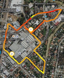
Walk 083 - Armadale's core

Date: 25th December
Distance: 2.68 kms
Locality: Armadale

Streets walked:
  • Whitehead Street
  • Hughes Road
  • Prospect Road
  • Third Road
  • Thomas Street
Running street count: 1001
Running distance count: 344.50 kms

Christmas Day was pretty much ideal for walking the final few streets of the challenge and the centre of Armadale was a fitting place to do it.

With no traffic, only four streets needed to make 1000, and a gorgeous 28 degrees max, this was a cakewalk and very enjoyable. Loping around the town centre at slow speed and taking note of all the changes that've happened here in the last four decades (if the memory doesn't cheat) finished things off a treat. It's been a good year, I've seen more of my hometown than ever, and loved it.

There may be one more blog entry to come, summarising things. In the meantime, have a pic:


20 Dec 2015

Walk 082 - Kelmscott Hills

Date: 20th December
Distance: 2.54 kms
Locality: Kelmscott

Streets walked:
  • Bromfield Drive
  • Rowley Street
  • Howard Place
  • Balgor Court
  • Kundyl Court
  • Anderson Place

Running street count: 996
Running distance count: 337.82 kms

As a kid riding around Kelmscott, no matter which type of bike you and your friends had, this set of streets (particularly Morrison which I didn't even attempt on this walk) rendered them futile; there was no option but to get off and push it uphill as best you could. This is steep country.

There are a lot of characterful homes around here trying to cling to the slopes to take best advantage of the views.


Just one of the many abandoned tennis courts of Kelmscott :(


Walk 081 - Sandy Sienna Wood

Date: 20th December
Distance: 1.68 kms
Locality: Hilbert

Streets walked:
  • Heartwood Way
  • Dalby Street
  • Gisburn Street
  • Bedgebury Road
  • Parkhurst Avenue
  • Eleventh Avenue

Running street count: 990
Running distance count: 335.28 km

This part of the Sienna Wood development is so new that some of the streets have yet to be created and not a single house has been started. An ideal traffic-less place to walk, really.

Once again the streets don't appear on the Runtastic app, but going to the City of Armadale's online mapping service shows the progress made on the estate up to September 2015 (see below). I can report that a lot more has been done since September, as the rest of the pics should show.

September's progress. How does it look three months hence? See below.
Now I know what the green stuff is for: to hold the sand down in high winds.


17 Dec 2015

Walk 080 - Riva on Piara

Date: 17th December
Distance: 4.77 kms
Locality: Piara Waters

Streets walked:
  • Torino Crescent
  • Calais Lane
  • Skeet Road
  • Rodez Link
  • Riva Entrance
  • Sativa Lane
  • Loseto Link
  • Royan Lane
  • Dijon Lane
  • Solingen Lane
  • Lanciano Lane
  • St Tropez Gardens
  • Monticello Parkway
  • Mataro Link
  • Passendale Crescent
  • Villatella Gardens
  • Novelli Parade
  • Riviera Turn
  • Calvera Gardens
  • Terracina Parkway
  • Albi Link
  • Varazee Way
  • Nitida Lane
  • Ortona Lane
  • Tordera Parkway
  • Vichy Close
  • Calamocha Way
  • Aleria Way

Running street count: 984
Running distance count: 333.60 kms

This walk in the still-underway estate of Riva on Piara Waters was easy, enjoyable, and got me a lot closer to the 1000-road goal (28 added to the list). Three observations were reinforced over and over as I walked around during the late afternoon:
  • Fake lawn (or to be generous, artificial turf) can get weeds in it. It was true when I last said it, it's still true now. All around its borders.
  • A big concentration of our new Australians are living here; almost every person I said waved to or had a chat with was from the Asian continent or the sub-continent. I'm no expert in picking where folks are from, but there were many Sikhs, Indians (or perhaps Pakistanis or Bangladeshis) and Chinese people out in their local parks, watering plants out the front, doing some work on their freshly-constructed homes. Piara Waters and Harrisdale are the cutting edge of Multicultural Australia.
  • There are some HUGE electricity pylons, the massive ones, running through the centre of this neighbourhood. Supposedly they can cause a number of health problems. I really hope not, or a lot of these residents are screwed.


Walk 079 - Blackwood

Date: 16th December
Distance: 2.92 kms
Locality: Mt Nasura

Streets walked:
  • Blackwood Drive
  • Nasura Grove
  • Oberon Grove
  • Vista Grove
  • Westview Close
  • Fisher Place
  • Valencia Grove

Running street count: 956
Running distance count: 328.83 kms

In the final days of this walking challenge I feel far less inclined to nitpick, criticise or complain about the neighbourhoods I go through. Hence there's not much comment here about Mt Nasura except for the pic captions.

Shout-out to Oberon Grove and the old Wheeler homestead.


This rock is way bigger than the pic indicates. Cool thing to have in your street!

From the rock above, you can have views like this.

Mazzega Park, presumably of Mazzega's Mitre 10 fame (now closed).

Walk 078 - Tait leftovers

Date: 14th December
Distance: 2.60 kms
Locality: Seville Grove

Streets walked:
  • Rupert Street
  • May Close
  • McKeown Court
  • Peel Court
  • Kootingal Road
  • Burran Court
  • Ives Place

Running street count: 949
Running distance count: 325.91 kms